

UPDATE: More evacuation orders lifted for Mt. Law fire
Due to reduced fire activity on the north end of the Mount Law wildfire, four properties on Turnbull Road have been downgraded from evacuation order to an alert.
“We saw some rain today in the wildfire area, which has helped the efforts of our fire crews and resulted in a decrease in fire activity,” said Jason Brolund, Fire Chief of West Kelowna Fire Rescue. “Crews continue to make good progress on the Mount Law wildfire, which remains active and out of control.”
The properties downgraded to evacuation alert include:
3704 Turnbull Road
3724 Turnbull Road
3725 Turnbull Road
3740 Turnbull Road
The following properties remain on evacuation order:
3713 and 3725 Emerald Road
3770 Turnbull Road
4713 MacKinnon Road
3250 Highway 97
All other evacuation alerts and orders remain in place. A detailed map showing the remaining alert and order areas is available at cordemergency.ca/map.
Returning residents are reminded that they may encounter various hazards on private properties as a result of the forest fire. Crews continue fire suppression in the area, and residents should stay out of the way of emergency vehicles and crews.
==
Planned ignitions continue on Mt. Law fire Aug. 22, 2021
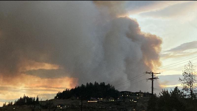
The Mount Law wildfire remains at 800 hectares in size, and crews will continue suppression efforts throughout the day. All evacuation orders and alerts for the fire remain in place.
At this time, crews have completed planned ignitions on the northern perimeter of the fire near Preston and Carre roads in West Kelowna. BC Wildfire Service may continue conducting small, planned ignitions today targeting the north, east and west perimeters of the fire.
“We want to remind residents that for their safety and that of emergency personnel they must not access the wildfire area or attempt to fight the fire on their own,” said Jason Brolund, Fire Chief of West Kelowna Fire Rescue. “The Mount Law wildfire remains active and considered out of control. Residents can be assured that we have a plan in place and are fighting fires where and when it is safe to do so.”
In addition to 82 firefighters from BC Wildfire Service, firefighting efforts are being supported by 33 structural firefighters from six fire departments along with 10 trucks and other equipment. If residents witness any spot fires threatening homes or other areas showing rapid growth, they should call 9-1-1 immediately, and fire crews will be directed to that area.
A detailed map of current Evacuation Alerts and Orders is available at cordemergency.ca/map.
==
The Mount Law wildfire remains at 800 hectares in size and crews will continue their suppression efforts throughout the day, including planned ignitions that may result in visible flames and smoke throughout the area. All evacuation orders and alerts for the fire remain in place.
At this time crews have established fire guards on the north, east and west sides of the fire. Today fire efforts will be focused on the south and south west perimeter of the fire.
BC Wildfire Services planned ignitions will target the south west corner of Drought Hill between the Mount Law fire perimeter and Highway 97C (Coquihalla Connector). Planned ignitions slated for last night did not proceed due to unfavorable conditions.
The wildfire is visible from Highway 97C and for the safety of travellers, motorists should not be stopping along the highway to observe or take photos of the wildfire and to allow crews to safely do their work. Motorists are to follow the direction of highway crews.
BC Wildfire crews have 45 firefighters and 31 pieces of heavy equipment on the ground in addition to fire fighting efforts being supported by firefighters from six fire departments (West Kelowna, Sundre Alberta, Woss Lake, Pt. McNeill, North Cowichan, Willowbrook). Four helicopters will continue to action the fire throughout the day.
“West Kelowna firefighters were out all night and will keep working aggressively today to fight the fire in tandem with the BC Wildfire Service, hitting the fire perimeter and monitoring hot spots,” says Jason Brolund, Fire Chief of West Kelowna Fire Rescue.
A detailed map is available at cordemergency.ca/map.
Last nights highly visible fire activity on the Mount Law fire is a reminder to all residents the fire is still considered out of control and residents need to continue to be vigilant. Residents can stay informed by signing up for e-updates at cordemergency.ca.
==
Aug 21, 2021 | 6:40 AM
Favourable weather has helped the efforts of crews fighting the Mount Law wildfire. As a result, eight properties on Gates Road have been downgraded from an evacuation order to an alert:
- 3658 to 3760 Gates Road
Although weather conditions are helping crews, all other existing orders and alerts remain in place. A detailed map is available at cordemergency.ca/map.
Residents returning to their properties are reminded that they may encounter various hazards as a result of the forest fire. As active fire suppression work continues throughout the area of the fire, please stay out of the way of emergency vehicles and crews. Do not block access to streets or properties.
“Crews are continuing fire suppression efforts within the fire perimeter and will monitor overnight,” said Jason Brolund, Fire Chief of West Kelowna Fire Rescue. BC Wildfire crews continue to action active fire areas on the hillsides with both air and ground support.
Firefighting efforts are being supported by 33 structural firefighters from six fire departments (West Kelowna, Sundre Alberta, Woss Lake, Pt. McNeill, North Cowichan, Willowbrook) along with 10 trucks and other equipment.
“Residents in the area can expect to see smoke and burning materials throughout the next few days as the fire burns near the top of the mountain but residents can be assured that West Kelowna crews, together with Peachland Fire Rescue, are closely monitoring conditions and will control the flare ups as necessary,” said Brolund.
Additional smoke or fire may also be visible because of controlled ignitions to strengthen fireguards.
The wildfire is visible from Highway 97C (Okanagan Connector) and for the safety of travellers, motorists are asked to refrain from stopping along the highway to observe the wildfire.
If residents witness any spot fires threatening homes or other areas showing rapid growth, they should call 9-1-1 immediately and fire crews will be directed to that area.
Burnt trees with little or no limbs have limited structural support and may fall at any time. Burning root structures leave the surrounding ground unstable and extremely hot. Wild animals may have been affected by the fire. If you spot an animal in distress, keep your distance and contact the Conservation Office at 250-828-2551.